Grassland monitoring for pastoralists
This page is a guide for installing monitoring sites, collecting data, and assessing change in grassland pasture condition over time.
The monitoring sites can be used to assess the impact of livestock and seasons on the health of the perennial vegetation. Importantly, the sites also enable land managers to know if their management is maintaining or improving pasture condition.
Why monitor?
Monitoring provides the information needed to plan and manage grazing pressure to maintain desirable perennials. Desirable perennials are the foundation of sustainable grazing in the rangelands.
Monitoring is needed to:
- know the current condition
- record your management
- measure change over time
- assess the effect of management on the changes.
What to monitor on these sites
For each site, you need to know:
- the vegetation type – grassland or shrubland
- the pasture type
- plant identification and indicator plants
- how to assess soil surface condition.
If you already know these things, read on. If you want to know how to do those things well, click on the links above.
Establishing a grassland monitoring system
We recommend 4 steps to establish a site:
- Select a location for each monitoring site within a paddock or management unit (or land system).
- Permanently mark the site with steel posts and pegs, and record the site characteristics (location and indicator species).
- Assess the site for the first time: frequency or number of indicator species and the baseline photograph.
- Make regular site assessments: we suggest monitoring sites at 3-year intervals.
Once you have selected a site, record the pasture type, and select indicator species to be monitored – record this on the Site installation sheet (Appendix A in the attached document).rec
Site location
Select sites for the long term and at least one in each paddock to monitor the influence of management.
Note: WARMS (Western Australian Rangeland Monitoring System) sites are not suitable for paddock- or lease-scale monitoring.
Choose pasture sites that are:
- preferred by livestock because these areas are the most valuable to a pastoral enterprise and are likely to be preferentially grazed
- responsive to grazing management (that is, in such a state that it can either improve or decline). Ideally, the site should contain 4 indicator species important to the pasture type: 2 desirable and 2 undesirable. At least 1 desirable species should be present. If no desirables are present, it is likely the location is unsuitable and another location should be chosen
- representative of a significant portion of the paddock or management unit
- at least 100m away from roads, fences or other structures that may modify grazing pressure
- easy to locate for re-assessment
- meet any regulatory requirements – lessees may be required under the Soil and Land Conservation Act 1945 and Land Administration Act 1997 to provide data demonstrating improved land management – locate sites that can provide this information.
Avoid placing sites on:
- pasture types or areas of low or very low productivity, e.g. hard spinifex, rocky outcrops (these areas are unlikely to show changes caused by grazing management)
- pasture types of insignificant area, e.g. a small patch of saltbush amongst mulga, or drainage tracts
- transition zones between pasture types
- areas likely to be affected by future development of fences, tracks or stock water.
Distance from water
Sites must be within the grazing radius of domestic livestock, but outside the ‘sacrifice zone’ adjacent to a livestock water point. Experience has shown that between 1.5 and 3 kilometres from a water point is applicable in most circumstances (Table 1). Salinity of the stock water and the pasture influences the grazing radius from watering points.
| Water quality | Grazing radius for saline (saltbush, bluebush or lakeside) pasture type | Grazing radius for non-saline (grassland, hummock grassland, mulga shrubland) pasture type |
| Less than 5000ppm (780mS/m) | 1.0–2.5km | 1.5–3.5km |
| More than 5000ppm (780mS/m) | 0.75–1.5km | 1.5–3.5km |
Mark out the site for long-term use
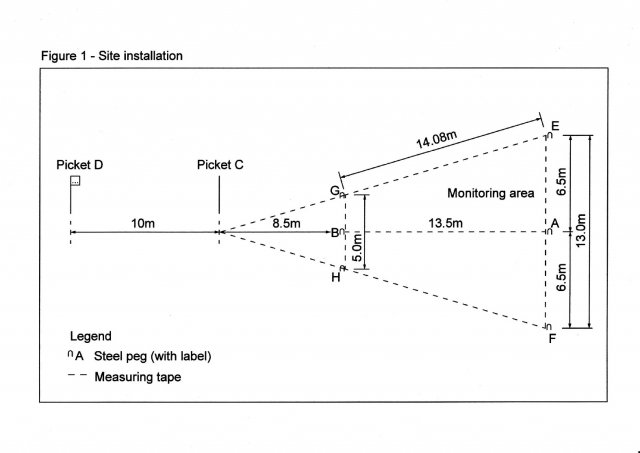
The layout design of a site in Figure 1 ensures data can be collected consistently across the lease and over time. This layout is the same for grassland and shrubland sites.
We recommend that the site is oriented North to South (sighting from picket D to peg A in Figure 1) to avoid taking photos into the sun. Also choose a site where pegs E and F are not obstructed by shrubs or trees (less likely in grassland sites).
Note: We recommend that you leave your vehicle at least 50m away from the site, and walk to the site to avoid damaging vegetation and possibly attracting stock and starting an erosion channel.
Equipment needed to establish the monitoring site
- 2 star pickets
- picket driver (dolly)
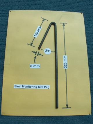
- 6 steel pegs (preferably galvanised) – see Figure 2
- hammer
- measuring tape (100m in length)
- permanent site identification tag (punched galvanised steel with wire fastener)
- site installation sheet (this needs to be stored somewhere safe)
- land system and station map (if available)
- GPS unit (if available).
Method for installing the monitoring site
- Step out the approximate boundary of the site to ensure the site area is appropriate. Make sure you can see the 2 steel pickets from the rear of the site, and that all the target species are contained within the site.
- Position steel peg A at the centre rear of the proposed site, as indicated in Figure 1.
- Position a second steel peg (B) at the centre front of the site 13.5m from the rear peg, along the axis of the site. Since a photograph needs to be taken, orientate the site more or less in a north-south direction to avoid taking a photograph directly into the sun.
- Position 2 star pickets (C & D) along the line of pegs A and B. The first star picket (C) should be located 22m from peg A (8.5m from peg B), and the second star picket (D) 32m from peg A (10m from star picket C). This will fix the exact location and orientation of the site. These steel pickets will help to re-locate the site.
- Position 2 steel pegs (E and F) 6.5m either side of the centre rear peg (A) as shown in Figure 1. Position another 2 steel pegs (G and H) 2.5m either side of the centre front peg (B). These mark the 4 corners of the site.
- Fix a permanent site identification tag to star picket D.
- While standing at star picket D, record and note down the GPS coordinates for the site and the access directions from the nearest permanently named point (e.g. windmill, yards) on the site installation sheet. Mark the site on a station map.
- Record the name of the nearest permanent water point and its distance (as the crow flies) from the monitoring site on the site installation sheet.
- Add all the relevant information to the site installation sheet.
Initial and subsequent site assessments
Assess the site in the first year to provide a baseline for rangeland condition trend. Then assess sites at 3 year intervals after the first assessment.
Grassland assessment determines the frequency of selected perennial grasses. Identifying these grasses is important – see the pasture condition guide for your area and pasture type (links below or to the right).
The following equipment is needed:
- 0.5m2 quadrat (70 x 70cm)
- measuring tape (100m)
- small signboard to display site identification and date (to display in the photographs of the site)
- tripod or other suitable support for signboard
- digital camera (preferably with GPS, and ability to zoom the lens – most smart phones are not suitable)
- site assessment recording sheets for grassland.
Grassland monitoring method
- With the 100m tape attached at B (Figure 1), mark out the perimeter of the site, via pegs G, then E, A, F, H, and back to B. Then, stretch the tape directly from B to A and attach it at A. Keep the tape taut, but not over-tight, at all times.
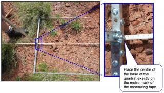
- Record species presence or absence at 2m intervals along the tape, starting at the 1m mark. Place the centre of the base of the quadrat exactly on the 1m mark of the tape (Figure 3). Repeat this procedure at exactly 2m intervals around the tape to give 25 frequency ratings per monitoring site (Figure 4).
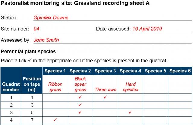
- On Grassland recording sheet A, record each grass species that is rooted within the quadrat, by placing a tick in the appropriate box (Figure 5). This is not a count of individual grass species, but recording of their presence or absence.
- Count and record the number of woody species (trees and shrubs greater than 1m high) within the area bordered by the tape.
- Assess the soil surface condition: examine the monitoring site, paying particular attention to the presence (or absence) of any material on the soil surface that would interrupt the flow of water (e.g. grass butts, leaf litter), and whether any soil is being lost to erosion. Classes for this assessment are listed on the site assessment recording sheet. Record this observation.
- Position the signboard for the photograph, preferably at or close to peg B (use a support if vegetation obscures the signboard). Write the site identification and date of assessment clearly on the board so they will be visible in the photograph.
- Stand at star picket C and photograph the site. Adjust the camera zoom so that the site perimeter is just inside the photograph, and keep a small amount of sky in the top of the image.
Note: While it may be preferable to take the photograph from an elevated position, such as from a stepladder, consider that all subsequent photographs will need to be taken from the same perspective.
Rangeland vegetation types
Pastoral rangelands in Western Australia occur as either grasslands (mostly in the northern rangelands) or shrublands (mostly in the southern rangelands). Grasslands and shrublands require different monitoring methods.
Vegetation types are characterised by their plant species:
- grasslands are characterised by perennial tussock and hummock grasses, and they occur primarily in the Kimberley and Pilbara regions
- shrublands are characterised by shrubs with a variable mulga (Acacia aneura) or eucalypt overstorey, and they occur primarily in the Gascoyne, Murchison, Goldfields and Nullarbor regions.
Shrublands and grasslands occur in the Gascoyne and Ashburton regions.
Grassland pasture types
Pasture condition is assessed on the plant species of a particular pasture type, and the ability of the soil resource to support plant growth.
A pasture is considered to be in good condition if vegetation composition, density and health is optimal considering the potential of the area. This assumes no grazing by introduced animals or increased grazing from native animals because of the additional watering points.
Identify and record the pasture type. That information is available from:
- Pasture condition guide for the Kimberley
- Pasture condition guide for the Pilbara
- Your nearest DPIRD pastoral officer.
Plant identification
Rangeland plants can be characterised as annuals, biennials or perennials:
- Annual plants, such as button grass or everlasting daisies, complete their life cycle within a single year.
- Biennial plants, such as limestone grass or roly poly, require more than 1 season to complete a life cycle, but rarely survive beyond 2 years.
- Perennial plants live for more than 2 years and include: trees, such as Bauhinia (Bauhinia cunninghamii) or beefwood (Grevillea striata); shrubs, such as silver saltbush or mimosa bush; and grasses, such as ribbon grass or woollybutt grass.
Pastoralism relies on production of good quality forage for livestock across a range of widely varying seasons. Palatable and productive perennials are good indicators of forage quality. Perennials survive through dry years and can maintain livestock when annuals fail to produce.
Plant information and photographs are in Common plants in the rangelands of Western Australia.
Using indicator plants to assess pasture condition
The presence, increase or decline in frequency of particular plant species – called indicator species – can reliably indicate the health of a grassland pasture and its change in condition over time.
Indicator species can be:
- Desirable: perennial plants that are productive and palatable to domestic livestock. These plants drive pastoral production. These are also called 'reducers', as heavy grazing pressure preferentially reduces or removes desirable perennial plants. A loss of these indicators shows a decline in pasture condition.
- Undesirable: plants that are unpalatable and of limited value to livestock production. Heavy grazing pressure tends to allow undesirable plabnts to increase (increasers) at the expense of desirable plants. This increase indicates a decline in range condition.
An improvement in pastoral vegetation condition is indicated by:
- an increase in the frequency of desirable perennial plants
- a reduction in the frequency of undesirables.
A decline in pastoral vegetation condition is indicated by:
- a reduction or loss of desirable perennial plants; heavy grazing pressure of rangeland pastures selectively removes desirable plants
- an increase in the frequency of undesirable plants.
Intermediate species include a large group of perennial plants that may or may not be palatable but typically do not increase to any great extent when more-palatable species are removed. The presence or absence of intermediate species should not be used as an indicator of pastoral vegetation condition.
We have shown the indicator value of many grassland pasture species in Common plants in the rangelands of Western Australia (on this website). For instance, ribbon grass.
Using the rangeland condition rating system
To get an overall rating for the site, use the matrix of soil erosion extent and pasture condition ratings to arrive at a rangeland condition rating (good, fair or poor) for each monitoring site or lease inspection point.
The Rangeland condition rating system page has the matrix, soil erosion and pasture condition ratings explained, with tables of the types of erosion assessed, and soil surface condition.
Trends in site condition
Monitoring over several years can show if the site condition is stable, improving (a positive trend) or declining (a negative trend).
Grassland condition trend is determined by changes in:
- frequency of the indicator perennial grass species – increased, decreased or the same
- density of woody species – increased, decreased or the same
- change in soil condition (if any), for example, poor to fair. over 2 or more monitoring intervals.
The trend can be used to check if grazing pressure is sustainable in a run of seasons.
Other indicators of rangeland condition trend
In grassland environments, an increase in the density of woody perennial plant species has the potential to suppress the growth of desirable perennial grasses and may make mustering more difficult. This change usually indicates a decline in rangeland condition.
While perennial grasses are usually a lesser component of shrublands, they are a primary driver of livestock productivity as well as performing an important ecological role. Therefore, the reduction or loss of perennial grasses in a shrubland environment may indicate a decline in rangeland condition.
Conversely, a reduction in woody species in grasslands or an increase in perennial grasses in shrublands, may indicate an improvement in rangeland condition.
What can influence the trend?
Factors include:
- What the seasons have been like – intensity and frequency of rain
- The total grazing pressure – stocking rate and presence of native or feral grazers
- Wildfire, floods and storms that affect vegetation and grazing habits.
Adapting management to influence trends
Use site data and assessments to help adapt management decisions.
- How can total grazing pressure be better managed?
- How can I reduce grazing pressure from native and feral grazers?
- What can I do to minimise the effect of wildfires and floods?
For more information
Contact one of the rangeland officers listed below.


