Recent climate
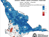
August rainfall was above average for the majority of the SWLD. The main rain event 16-18 August, was due to a rainband linking up with a cold front. August maximum temperatures were average, with minimum temperatures mostly close to average. Widespread frost has recorded for the last three days of August. Rainfall decile map for 1 April to 4 September 2022 shows decile 8-10 rainfall for the majority of the South West Land Division.
In August the atmospheric pressure was near normal over the SWLD.
Sea surface temperatures have remained warmer than average around much of the Australian coastline, particularly to the north and west. The sea surface temperature outlook for September to October by the Bureau of Meteorology indicates SSTs are likely to remain warmer than normal around Western Australia and the north and south-east of Australia.
A negative Indian Ocean Dipole (IOD) event continues, and model outlooks indicate it is likely to persist into late spring (November). A negative IOD increases the chances of above average winter–spring rainfall for much of Australia. Past negative IOD events generally increase rainfall in the eastern grainbelt.
The Southern Annular Mode (SAM), also known as the Antarctic Oscillation (AAO), describes the north–south movement of the westerly wind belt that circles Antarctica, dominating the middle to higher latitudes of the southern hemisphere. SAM is currently strongly positive. Values are expected to be generally positive throughout spring and into early summer. A positive SAM has a drying influence for parts of south-west and south-east Australia at this time of year. For more information see the Bureau of Meteorology’s Climate Driver Update.
The El Niño–Southern Oscillation is currently neutral. The Bureau's ENSO Outlook continues at La Niña ALERT, indicating at least a 70% chance of La Niña reforming later this year. This is around triple the normal likelihood. La Niña events increase the chances of above-average rainfall for northern and eastern Australia during spring and summer. In past La Niñas, summer rainfall has been generally average in the South West Land Division.
The table below gives a summary of past month and three-month South West Land Division (SWLD) climate conditions, and can indicate what is likely to occur in the near future if climate conditions follow the current pattern.
| Climate Indicator | Past month | Past 3 months |
|---|---|---|
| SWLD Rainfall | Average to above average | Above average |
| SWLD Mean Temperature | Below average to average | Average to above average |
| SWLD atmospheric pressure | Normal | Higher |
| Indian Ocean Sea surface temperature | Warmer | Warmer |
| El Niño/Southern Oscillation (ENSO) | Neutral | Neutral |
| Indian Ocean Dipole (IOD) | Negative | Negative |
| Southern Annular Mode (SAM) | Positive | Positive |