Summary
The Department of Primary Industries and Regional Development’s (DPIRD) Statistical Seasonal Forecast (SSF) outlook for winter, June to August 2021 is indicating less than 40% chance of exceeding median rainfall for the majority of the South West Land Division (SWLD). The SSF longer outlook for June to October is similar.
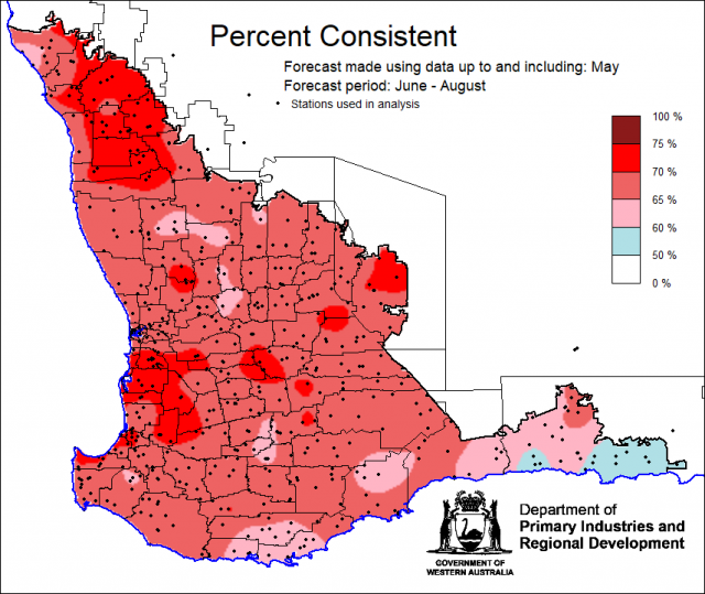
- For winter, June to August 2021, the SSF is indicating less than 40% chance of exceeding median rainfall for the majority of the South West Land Division (SWLD). The most probable rainfall decile map indicates decile 2-3 for the SWLD. Predictive skill based on May conditions is mostly poor to good (50-75% consistent).
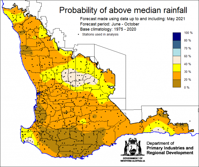
- The longer lead SSF forecast for June to October 2021 rainfall is indicating less than 40% chance of exceeding median rainfall for the majority of the SWLD. Most likely decile range maps is indicating decile 2-3 for the SWLD. Skill is poor to good at 50 to 100 % consistent.
- The Bureau of Meteorology’s seasonal outlook for winter, June to August indicated 30-50% chance of exceeding median rainfall for the SWLD. Predictive skill is poor to moderate (50-65% consistent). The current outlook for July to September is similar, 35-65% chance of exceeding median rainfall with higher chances along the southern coast. Skill is poor to moderate (45-65%).
- Temperature outlooks for winter June to August 2021, from the Bureau indicate a 50-80% chance of above average day-time maxima (skill 75-100%) and 55-80% chance of exceeding above average night-time minima for most of the SWLD (skill 45-65%).
- May rainfall was very much above average for SWLD due to a series of cold fronts. Autumn rainfall, March to May was decile 8-10 for most of the SWLD, wettest since 2016. May maximum temperatures were generally average. Minimum temperatures were above average to very much above average.
- The Southern Annular Mode is the main climate driver for the SWLD in winter, when it is in a negative phase it brings more rain, it is forecast to be neutral until the end of June.
Three Month Outlook for the south-west of Western Australia
Statistical Seasonal Forecasting (SSF)
DPIRD’s Statistical Seasonal Forecast (SSF) system uses historical relationships between global sea surface temperature and sea level pressure with rainfall in south-west Australia to produce forecasts of rainfall for the coming months. Users can click on any station indicated on the map for location-specific forecast information from DPIRD's Seasonal Climate Information pages.
For winter, June to August 2021, the SSF is indicating less than 40% chance of exceeding median rainfall for the majority of the South West Land Division (SWLD). The most probable rainfall decile map indicates decile 2-3 for the SWLD. Predictive skill based on May conditions is mostly poor to good (50-75% consistent).


Bureau of Meteorology seasonal climate outlook
The Bureau of Meteorology's climate forecast system for monthly and seasonal climate outlooks is the Australian Community Climate Earth-System Simulator – Seasonal (ACCESS-S). It is a dynamical (physics-based) forecast modelling system and is a collaboration between the Bureau of Meteorology and the UK Meteorological Office.
The Bureau of Meteorology’s seasonal outlook for winter, June to August indicated 30-50% chance of exceeding median rainfall for the SWLD. Predictive skill is poor to moderate (50-65% consistent). The current outlook for July to September is similar, 35-65% chance of exceeding median rainfall with higher chances along the southern coast. Skill is poor to moderate (45-65%).
Temperature outlooks for winter June to August 2021, from the Bureau indicate a 50-80% chance of above average day-time maxima (skill 75-100%) and 55-80% chance of exceeding above average night-time minima for most of the SWLD (skill 45-65%).

Looking at other rainfall forecasting models, four of the models are suggesting neutral and four of the models are suggesting neutral to above median rainfall for the SWLD for winter, June to August 2021.

SSF Forecast for June to October
The SSF forecast for SWLD June to October 2021 rainfall is indicating less than 40% chance of exceeding median rainfall for the majority of the SWLD. The most likely decile range maps is indicating decile 2-3 for the SWLD. Skill is poor to good at 50 to 100 % consistent.


Recent climate
May rainfall was very much above average for SWLD due to a series of cold fronts. Autumn rainfall, March to May was decile 8-10 for most of the SWLD, wettest since 2016. May maximum temperatures were generally average. May minimum temperatures were above average to very much above average. Rainfall decile map for 1 April to 7 June shows decile 8-10 rainfall for the majority of the SWLD.
In May the atmospheric pressure was slightly higher than normal over the SWLD.
Large parts of the eastern Indian Ocean have sea surface temperatures which are warmer than average which can favour above average rainfall for parts of Australia.The June to August 2020, SST forecast by the Bureau of Meteorology indicates SSTs are likely to remain warm north of WA.
The Southern Annular Mode (SAM), also known as the Antarctic Oscillation (AAO), describes the north–south movement of the westerly wind belt that circles Antarctica, dominating the middle to higher latitudes of the southern hemisphere. When SAM is negative in winter, rainfall increases over SWLD, as was the case in mid to late May. SAM is currently neutral and it is forecast to remain neutral until the end of June. For more information see the Bureau of Meteorology’s Climate Driver Update.
The Indian Ocean Dipole (IOD) is currently neutral. The Bureau predicts a negative IOD for winter, meaning more rain for the eastern grain-belt. The European Centre of Medium-Range Weather Forecasts (ECMWF) model indicates a negative IOD in September. However, it should be noted that model accuracy is low at this time of the year, so the current outlooks should be viewed with caution. Model accuracy improves for forecasts made during winter.
The El Niño–Southern Oscillation (ENSO) is neutral. Climate model outlooks show this neutral ENSO state is likely to continue through winter and into spring. Neutral ENSO has little influence on Australian weather and climate and means the effects of the other climate drivers may dominate this season.
The table below gives a summary of past month and three-month South West Land Division (SWLD) climate conditions, and can indicate what is likely to occur in the near future if climate conditions follow the current pattern.
| Climate Indicator | Past month | Past 3 months |
|---|---|---|
| SWLD Rainfall | Decile 8-9 | Decile 8-9 |
| SWLD Mean Temperature | Above average | Very much above average |
| SWLD Mean Sea Level Pressure | Slightly higher | Near normal |
| Indian Ocean Sea Surface Temperature | Warmer | Warmer |
| El Niño/Southern Oscillation (ENSO) | Neutral | Neutral |
| Indian Ocean Dipole (IOD) | Neutral | Neutral |
| Southern Annular Mode (SAM) | Negative | Positive |


