Summary
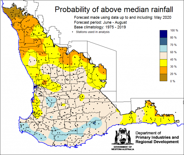
The Department of Primary Industries and Regional Development’s (DPIRD) Statistical Seasonal Forecast (SSF) outlook for winter, June to August and June to October 2020 is indicating less than a 40% probability of above median rainfall for the Central West, Central Wheatbelt, South East Coastal and parts of the Lower West Districts of the South West Land Division. Neutral odds apply elsewhere.
- For winter June to August 2020, the SSF is indicating less than a 40% chance of exceeding median rainfall for the Central West, Central Wheatbelt and South East Coastal Districts, with neutral odds elsewhere. The most probable rainfall decile map indicates decile 2-3 for Central West, Central Wheatbelt, South East Coastal and parts of the Lower West Districts. Decile 4-7 rainfall is likely elsewhere. Predictive skill based on June conditions is poor to good (50 -75% consistent).
- For June to October, the SSF is indicating less than a 40% chance of above median rainfall for parts of the Central West, Central Wheatbelt and South East Coastal Districts, neutral odds elsewhere. The most probable rainfall decile map indicates decile 2-3 for the Central West, Central Wheatbelt and South East Coastal Districts. Decile 4-7 rainfall is forecast for the remainder of the SWLD. Predictive skill based on June conditions is poor to good (50 -75% consistent).
- The Bureau of Meteorology’s current seasonal outlook is indicating close to neutral chances (45-60%) of exceeding median rainfall for winter, June to August 2020. Predictive skill is poor to good (45-75% consistent). The longer-term outlook for July to September, is for wetter conditions. Predictive skill is 50-65% consistent.
- Temperature outlooks for winter, June to August 2020, from the Bureau indicate a 50-65% chance of above average day-time maxima (skill 55-65%) and a 50-70% chance of above average night-time minima (skill 50-65%) for the SWLD.
- May rainfall was mostly below average across cropping regions, although some parts in the south and around Merredin received decile 8-9 rainfall. Autumn, March to May, rainfall was below average in the north and only near average in the south-west corner. May maximum temperatures were average to above average. May minimum temperatures were below average to average.
- The early part of winter rainfall for the SWLD may be drier than normal due to a positive Southern Annular Mode that is predicted to persist though June.
- Winter and spring rainfall may be influenced by a negative Indian Ocean Dipole (IOD). This is forecast to develop from late July and persisting until October. A negative IOD typically brings above average winter–spring rainfall to southern Australia. However, for south western WA some negative IOD years have been drier than normal, such as 2010 and 2016.
Three Month Outlook for the south-west of Western Australia
Statistical Seasonal Forecasting (SSF)
DPIRD’s Statistical Seasonal Forecast (SSF) system uses historical relationships between global sea surface temperature and sea level pressure with rainfall in south-west Australia to produce forecasts of rainfall for the coming months. Users can click on any station indicated on the map for location-specific forecast information from the Seasonal Climate Information web page.
For winter June to August 2020, the SSF is indicating less than a 40% chance of exceeding median rainfall for the Central West, Central Wheatbelt and South East Coastal Districts, with neutral odds elsewhere. The most probable rainfall decile map indicates decile 2-3 for Central West, Central Wheatbelt and South East Coastal Districts. Decile 4-7 is expected elsewhere. Predictive skill based on June conditions is poor to good (50 -75% consistent).


