Goat control on Charles Darwin Reserve

Charles Darwin Reserve is a 68 000 ha conservation reserve on privately owned land. It contains some of the largest areas of intact native vegetation in the wheatbelt, including large stands of York gum and salmon gum woodlands, which have largely been cleared elsewhere in the region.
The reserve also provides habitat for at least 11 threatened species, and additional significant species continue to be discovered.
Erosion and overgrazing caused by feral goat activity is threatening the health and survival of significant vegetation communities and threatened species within the reserve, particularly around watering points. Restricting access to watering points and trapping has proven to be effective in reducing feral goat numbers.
State NRM Program funds were used by this project to fence two watering points (dams) on the reserve. Spear traps were also installed to allow for ongoing management of goat numbers.
Investment: $ 19 000
Delivery organisation: Bush Heritage Australia
Project duration: April 2010 - June 2011
Location: Charles Darwin Reserve (formerly White Wells Station). The property is in the Northern Agricultural region, north-east of Wubin on the Great Northern Highway and west of Mt Gibson
Major project achievements
Two dams fenced, complete with access and trap gates.
Fences upgraded and maintained around three other dams. Over time, this will reduce numbers of goats in the reserve, enabling groundcover and trees around watering points to regenerate. This will reduce bank erosion and allow populations of threatened flora to increase or stabilise.
Hand weeding and mapping in Queens Park Reserves
Queens Park Regional Open Space includes Bush Forever sites 283 and 424, which contain threatened ecological communities, declared rare flora and priority flora. This bushland provides habitat to 100 recorded bird species, including the endangered Carnaby's black-cockatoo and migratory rainbow bee-eater as well as 14 reptile species.
While the bushlands are fragmented and disturbed by weed invasion, a recent report, Flora and Fauna Assessment for Queens Park Regional Open Space (Ecoscape Pty Ltd, 2010), identified the vegetation condition in many areas as very good to excellent.
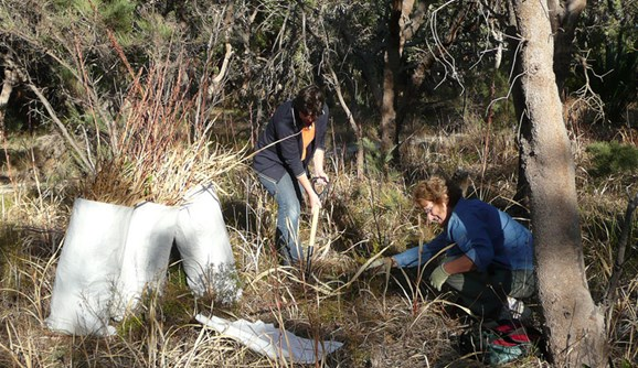
With the help of State NRM Program funding, environmental weeds will be removed by hand from better vegetation condition areas in the threatened ecological communities. Hand weeding is best in areas with declared rare flora, priority flora and smaller herbs such as orchids, which are easily killed from overspray of poisons. Selective herbicide will be used in other areas to control grass.
Maps of the distribution of priority weeds will also be produced to enhance the efficiency of this and future weed control projects.
Investment: $ 30 400
In-kind contribution: $ 8 581
Other contribution: $ 20 895
Delivery organisation: City of Canning; Friends of Queens Park Bushland
Project duration: July 2011 - June 2012
Location: Queens Park Regional Open Space, 11 km south-east of Perth in Queens Park, East Cannington and Welshpool
Major project achievements
- Reserves are now almost free of Bridal creeper; are free of Geraldton carnation weed; and all Watsonia has been treated.
- Occurrence of Pink gladiolus has been greatly reduced by hand weeding and control of non-native grasses had improved.
- Six priority weeds were mapped to aid future management activities.
- Three public walks were held with a number of new people attending.
Dieback mapping and treatment
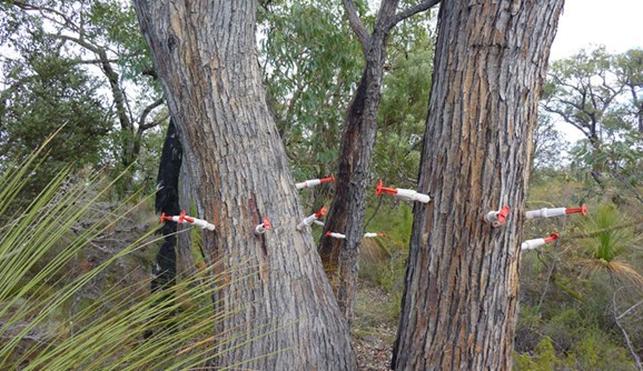
Dieback disease is invading bushland reserves, threatening biodiversity and degrading ecological linkages throughout the Ellen Brockman region. Mapping the extent of dieback is critical to its management.
With the help of State NRM Program funding, this project will map four reserves where the threat of dieback is suspected. Once the threat is assessed, action will be taken to reduce the spread. Three other infested reserves also will be treated.
A workshop for the local community will be held as part of this project to raise awareness of the disease.
Investment: $ 39 384
In-kind contribution: $ 38 600
Other contribution: $ 784
Delivery organisation: Ellen Brockman Integrated Catchment Group
Project duration: February 2012 - June 2012
Location: Various reserves in the City of Swan and Shire of Chittering
Major project achievements
Dieback in 8 reserves mapped.
15 hectares of dieback affected area treated.
A total of 16 signs were erected in dieback free and infested areas within the mapped reserves.
30 people attended an informative community workshop.
Project partners
Shire of Chittering; City of Swan; North Swan Landcare Group; Chittering Valley LCDC; Chittering Landcare Centre
Restoring biodiversity to the central wheatbelt
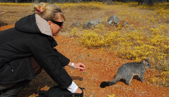
Wadderin Sanctuary is a 430 hectare predator-free area in the central wheatbelt established by the local community of Narembeen.
The sanctuary is being used to reconstruct the pre-European fauna species lost to introduced predators and land-clearing.
Five threatened mammal species and one bird species have been reintroduced. These are the red-tailed phascogale, woylie, quenda, brushtail possum, brush wallaby and curlew.
Wadderin is the only reserve in the central wheatbelt fenced to exclude exotic predators.
This project will contribute towards the following activities:
maintain the site free of foxes and feral cats by regular inspection and maintenance of the barrier fence, as well as baiting for foxes and trapping for feral cats as required
monitoring of reintroduced fauna (trapping at 3-4 month intervals for woylie, quenda, and possum; monitoring of nest boxes for phascogale; monitoring of nocturnal calls for bush stone- curlew; camera traps and spotlighting for brush wallaby) to confirm their establishment and persistence
reintroduce at least one other threatened species. This species is likely to be either the black-flanked rock-wallaby (vulnerable) or the malleefowl (vulnerable)
development of an interpretative sign at the front gate of the sanctuary
extend the benefits to neighbouring remnants and adjoining bushland by adding nest boxes for red-tailed phascogale to adjoining and nearby bushland.
Investment: $ 29 737
Delivery organisation: Wadderin Group
Project duration: January 2013 - December 2013
Location: Narembeen, in the east-central wheatbelt of Western Australia
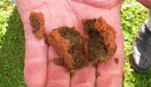
Dung beetles improve soil fertility