Do you use the PestFacts WA map?
The PestFacts WA map is a portal to extensive insect and disease data from the WA grainbelt. Growers and consultants may be surprised by the tool’s usefulness, if they are not already regularly generating maps.
What is the PestFacts WA map?
The PestFacts WA map provides a visual display of all pest and disease occurrences reported by the WA grains industry to the PestFacts WA (formerly PestFax) service since 1996.
How do I check what has been reported?
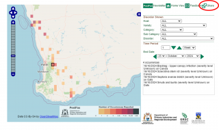
Viewers can select a host, disorder and time period in the PestFacts WA map, see screenshot below.
Reported occurrences are displayed as colour coded squares. Viewers can click on any square to see more detail, see screenshot below.
Viewers can compare report numbers and patterns between seasons and see how pests and diseases spread within a season.
Maps can be produced showing individual disorders, totals for disorder categories, or overall disorder totals.
I have found an insect or disease in my crop or pasture – how do I report it?
Reports can be made to the PestFacts WA team by either:
- downloading and using the PestFacts WA Reporter app
- emailing the PestFacts WA team via pestfactswa@dpird.wa.gov.au or
- phoning PestFacts WA newsletter editor Cindy Webster on +61 404 819 534.
The more reports received and mapped, the better growers and consultants are forewarned about emerging pest issues in their areas. Reporting both the presence and absence of common diseases or pests multiple times is encouraged to build a more detailed ‘picture’ of their distribution and severity.
How do I share a generated map with someone else?
Select 'share' and copy the map link. The link can be inserted in a document or sent in a message, allowing readers to click and view the same map.
PestFacts WA map project history
The former PestFax map service was developed through two successive projects jointly funded by the Grains Research and Development Corporation (GRDC) and DPIRD from 2010 to 2016. These projects were in partnership with Cesar Australia, the South Australian Research and Development Institute (SARDI) and the Australian Cereal Rust Control Program (ACRCP) at the University of Sydney.
Further information
For more information, or to generate a map, visit DPIRD’s PestFacts WA map.
For more information contact Cindy Webster, Research Scientist in Narrogin on +61 8 9881 0201.
Article author: Cindy Webster (DPIRD Narrogin).


