Summary
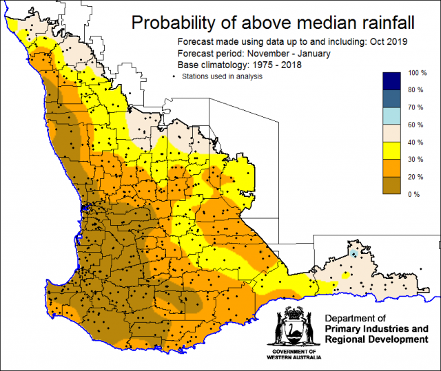
The Department of Primary Industries and Regional Development’s (DPIRD) Statistical Seasonal Forecast (SSF) outlook for November 2019 to January 2020 is indicating less than 40% chance of exceeding median rainfall for the majority of the South West Land Division (SWLD).
- For November 2019 to January 2020, the SSF is indicating less than 40% chance of exceeding median rainfall for the majority of the South West Land Division. For Esperance shire, the chance is higher at 40-60% (neutral). The most probable rainfall decile map indicates decile 1-3 for SWLD. Predictive skill based on October conditions is poor to good (50 -70% consistent).
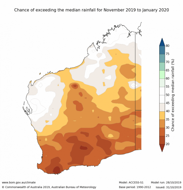
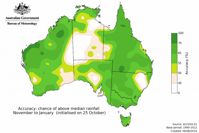
- The Bureau of Meteorology’s current seasonal outlook is indicating 20-30% chance of exceeding median rainfall for November 2019 to January 2020, for most of the South West Land Division. Predictive skill is poor to good (50-75% consistent).
- Temperature outlooks for November 2019 to January 2020, from the Bureau indicate an 80% chance of above average day-time maxima for the SWLD. Skill is good at 65-100% consistent. Minimum temperature outlooks indicate a 60-80% chance of above average night-time minima for the SWLD, with skill good at 65-100% consistent.
- October rainfall was below average to average for the SWLD. October maximum and minimum temperatures were above average.
- The strong positive Indian Ocean Dipole (IOD) is continuing to influence Australian climate, while a negative Southern Annular Mode (SAM) is likely to influence Australia for the coming weeks.
Three Month Outlook for the south-west of Western Australia
Statistical Seasonal Forecasting (SSF)
DPIRD’s Statistical Seasonal Forecast (SSF) system uses historical relationships between global sea surface temperature and sea level pressure with rainfall in south-west Australia to produce forecasts of rainfall for the coming months. Users can click on any station indicated on the map for location-specific forecast information from the Seasonal Climate Information [1] web page.
For November 2019 to January 2020, the SSF is indicating less than 40% chance of exceeding median rainfall for the majority of the South West Land Division. For Esperance shire, the chance is higher at 40-60% (neutral). The most probable rainfall decile map indicates decile 1-3 for the majority of the SWLD. Predictive skill based on October conditions is poor to good (50 -70% consistent).
 [2]
[2] [3]
[3]Bureau of Meteorology seasonal climate outlook
The Bureau of Meteorology's climate forecast system for monthly and seasonal climate outlooks is the Australian Community Climate Earth-System Simulator – Seasonal (ACCESS–S [4]). It is a dynamical (physics-based) forecast modelling system and is a collaboration between the Bureau of Meteorology and the UK Meteorological Office. The Bureau of Meteorology’s current seasonal outlook is indicating 20-30% chance of exceeding median rainfall for November 2019 to January 2020, for most of the South West Land Division. Predictive skill is poor to good (50-75% consistent). Temperature outlooks for November 2019 to January 2020, from the Bureau indicate an 80% chance of above average day-time maxima for the SWLD. Skill is good at 65-100% consistent. Minimum temperature outlooks indicate a 60-80% chance of above average night-time minima for the SWLD, with skill good at 65-100% consistent.
 [5]
[5]Recent climate
October rainfall was below average to average for the SWLD. October maximum and minimum temperatures were above average. The 2019 growing season rainfall (May to October) was generally below average (decile 2-3) for the SWLD.
In October, the atmospheric pressure [8] [8]was slightly above normal over the SWLD.
Indian Ocean sea surface temperatures [9] off the WA coastline have been cooler than average. The November 2019 and January 2020, SST forecast by the Bureau of Meteorology [10] indicates SSTs are likely to be warming up north of WA.
The Southern Annular Mode (SAM), also known as the Antarctic Oscillation (AAO), describes the north–south movement of the westerly wind belt that circles Antarctica, dominating the middle to higher latitudes of the southern hemisphere. SAM has been negative since July and is forecast to remain negative during November. A neagative SAM increases the chance of spring heatwaves occurring across southern Australia.
The strong positive Indian Ocean Dipole (IOD) continues. A positive IOD generally means below average spring rainfall for much of the central and southern Australia, and warmer than average daytime temperatures for the southern two thirds of Australia. IOD events typically have little influence on Australian climate from December to April, however, given that this positive IOD is so strong, it is likely to take several weeks to decline, and could persist well into mid-summer. The El Niño–Southern Oscillation (ENSO) is expected to remain neutral for the remainder of 2019. For further information, see the Bureau of Meteorology’s ENSO Wrap Up [11].
The table below gives a summary of past month and three-month South West Land Division (SWLD) climate conditions, and can indicate what is likely to occur in the near future if climate conditions follow the current pattern.
| Climate Indicator | Past month | Past 3 months |
|---|---|---|
| SWLD Rainfall [12] | Below average to average | Below average |
| SWLD Mean Temperature [13] | Above average | Very much above Average |
| SWLD atmospheric pressure [8] | Above Normal | Above Normal |
| Indian Ocean Sea surface temperature [14] | Cooler | Cooler |
| El Niño/Southern Oscillation [11] (ENSO) | Neutral | Neutral |
| Indian Ocean Dipole [15] (IOD) | Positive | Positive |
| Southern Annular Mode [16] (SAM) | Negative | Negative |


